Iran lakes
Persian dish
April 14, 2020Is Damavand height 5671 meters?
May 5, 2020Iran lakes
We try to talk about Iran and most famous lakes in it.
Climbers should, as far as possible, prevent harmful human encroachments on nature and fight against such movements. Closing the dam on the Telovar River, which is one of the main tributaries of the Ghezel Ozan River, to transfer water to the villages and the city of Garmab is one of the most harmful and unexplored works due to its proximity to Katal-e-Khor Cave, Which is one of the rare caves in Iran. It causes damage and destruction. The cave is unlikely to be destroyed due to the infiltration of the dam’s lake water from limestone crevices and crevices, the cave’s karst and its conversion into an underground water reservoir. It will be one of the water resources of Gilan province.
To maintain any natural phenomenon, it must first be known quantitatively and qualitatively. Obtaining accurate information is an effective aid in its protection. The ecosystem of natural phenomena should never be changed because this change will destroy or destroy it. For example, the seasonal drying of the Ghezel Ozan River due to excessive water withdrawal from its upper parts will cause a drop in the stagnant surface in the bed area and especially cause the destruction and collapse of the one-hectare and vertical wall of Behistan historical castle near Mahneshan city.
As for the lakes introduced in this article, I have said that I have personally visited all the lakes I have mentioned more than twice and used several resources about them, the most important of which are books (Iranian seas and lakes) by Mr Mostafa Shahrabi, published in 1373, and all the figures are from that book, and it should be noted that these figures in that book do not correspond to reality at present, because for many reasons the water of the lakes Non-mountainous has fallen or dried up, such as Lake Urmia and Lake Parishan.
But before introducing lakes, one must first study a few geological terms.
1) Geosynclinal or non-geochemical Iran lakes:
Some of Iran lakes are separated as a result of the erosion of the earth’s crust on both sides and create a challenge between them. These masses of several thousand meters are accumulated in the form of thick and thin horizontal layers due to rainfall and erosion and carrying those materials in the challenge. And it folds itself into the ground as a result of subsequent movements and gives rise to mountains and pains
2) Plate tectonics Iran lakes:
According to this theory, the Earth’s crust consists of a number of about 13 broken and glued plates that are constantly moving on the inside of the bamboo paste. They cross each other and sometimes move towards each other and push each other, resulting in the birth of its long mountain range in western South America and the Himalayas in India.
Faults are fractures inside large plates that are found in large numbers inside the main plates
Types of Iran lakes
– Tectonic depression Lakes
– Nudist holes Lakes
– Volcanic craters Lakes
– Lakes from the sale of celestial rocks, which probably do not exist in Iran
– The dam lakes, the exact example of which is in the current location of Lar Dam, and then in the past were destroyed by floods and the dam wall was built on the site.
And now the introduction of Iranian lakes
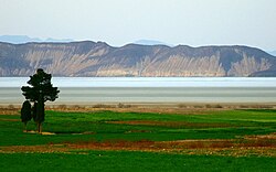
1- Lake Urmia:

Urmia is the largest Iran lakes and one of the tectonic lakes with an area of about 0.50 square kilometres and a length of 140 kilometres. The blue is saturated and has been talked about in history books due to its vastness and location. Its surface is 1300 meters above sea level and its deepest part is 13 meters. This lake is the terminal of 14 permanent rivers that enter it from four geographical directions, among which we can mention the two rivers of Zarrinhrud originating from Marivan and Simineh Rud rivers and originating from the mountains of southern Azerbaijan.
2- Lake Neyriz:
This lake consists of two lakes, Bakhtegan in the south and in another way called Tashk in the north. Both lakes were born in a tectonic depression in which the main Zagros fault played a role. The height of Lake Neyriz is 1560 meters above sea level. And it has an area of 750 square kilometres. A number of islands are located on both lakes.
The catchment area with the song of the lake has a catchment area of about 2000 square kilometres, but most of the incoming rivers are seasonal or permanent news. It flows into both lakes from the western part and there are other springs whose outlet is in the area of the lake itself and the water is due to annual rainfall. The lakes are home to different species of native and migratory birds.
3- Tar and Havir Lake:
These two freshwater lakes are located on the southern slope of Qara Dagh mountain range and below the slopes of the peak. It is about one kilometre apart. Hoyer is located in the east of Tar and its deepest part is 25 meters and its deepest hyena is about 0 meters. Both lakes are located at an altitude of about 2900 meters above sea level and the area of both is about 0.7 km. The longest length of Lake Tar is 1.3 km and Havir is 900 meters. Flower movements have increased and both lakes have been born. The water of both lakes is the result of snow and rain on the slopes of Qara Dagh
The water of Tar Lake flows towards Damavand city and Havir flows towards Firooz Kooh city. Since the lakes are among the most beautiful mountain lakes in Iran, they are called the access route
Tar route from Tehran Roodehen – Abali – Damavand and Havir route – Tehran- Roodehen – Firoozkooh road, Delichai big bridge – left side of the side road of Aro village – Havir
4- Disturbed or Famour Lake:
Disturbed Lake was formed in tectonic subsidence in which the Kazerun fault was involved and was about 800 meters above sea level. Disturbed area is about 40 square kilometres and 15 kilometres in return. The distance of the lake from Kazerun city is 15 km. Its catchment area is 160 square kilometres and its water was supplied through several seasonal waterways and a number of surrounding springs. The lake has been home to native and migratory birds. But those who are thinking of reviving the lake should be told that the lost water will not return to the atmosphere.
5- Hoz-e-Sultan Lake:
This lake is located on the eastern side of the 90th kilometre of Tehran-Qom road and consists of two pits called Hoz-e-Soltan and Hoz-e-Marah and their height is 800 meters above sea level. The origin of that tectonic movement is in its location. Its juicy part is 100 square kilometres and its length is 15 kilometres. The two rivers Qarachai and Rudsur feed the lake. The lake is currently a source of sea salt
6- Zarivar:
Location, Zarivar Lake is located 8 km away from Marivan city and is one of the freshwater lakes of Keshun. It is about 800 meters above sea level and has an area of about 8 square kilometres, the deepest part is about 50 meters and the longest is 5 kilometres. The lake was born in tectonic subsidence that was the result of the activity of the main Zagros fault (Sanandaj-Sirjan fault). Its catchment area is about 500 square kilometres. The lake is the terminal of the two rivers Cham Gardan and Cham Ghazli Su. There are a number of springs in and around the floor that provide water.
Zarivar is located in 600 mm of annual rainfall, which has become a forest of apples and the growth of various plants and has created tourist attractions.
7- Gavkhoni swamp:
Gavkhoni swamp is located 60 km south of Nain city. The way to reach it is from Nain with Isfahan to the small town of Kuhpayeh. This road passed Harand and Varzaneh and passing through the asphalted road of Shahkhan. Its water is very shallow and the floor is stiff and it can be walked for miles. The road (Varzaneh – Shakh Kanar) is parallel to the Zayandehrud riverbed and can be walked to the water on foot from the road at any time. The swamp is about 480 square kilometres and has a length of about 35 kilometres. Its surface is 1,500 meters above sea level.
Was Gavkhoni swamp born in a tectonic subsidence?
The area around Gavkhoni is made up of short volcanic mountains and sand dunes, and flatlands. Swamp catchment is one of the annual rainfalls and several permanent rivers, including the Zayandehrud River, which originates from Zardkooh Bakhtiari fertilizers and after storing some of its water behind the Shah Abbas Dam, it overflows to Isfahan and then Gavkhoni Swamp. Gavkhoni has located in a hot and desert region and its water evaporation is too normal. In recent years, some of the springs of Zayandehrud have been transferred to other cities, and as a result, its discharge to Gavkhoni has decreased. It remains to be seen whether the desert will remain dry and cracked. While we need to be aware that swamp water and lakes are effective factors in keeping groundwater aquifers high in their locations.
8- Gahar Lake:
This lake is one of the mountainous and freshwater and beautiful lakes of Iran, which is located between the two mountain ranges of Ashtran Kooh and Sar Sabz Kooh. There is a three-hour walk from the parking lot to the lake. The location of the lake is covered with forest trees and flowers and plants.
Where is Geographical Gahar location?
The surface of the lake is 2300 meters above sea level and consists of two smaller lakes at the top and larger at the bottom. The catchment area of the lake is 75 hectares and its length is 2 km. Ab Gohar joins the Caesar River through the beautiful and long valley of Negar and passing through several villages at the Cham Chid railway station. The source of Gohar water is water from annual rainfall and numerous underwater springs inside it.
What is Geology of Gahar Lake:
The lake is the result of faults and faults that pass between the two mountain ranges of Ashtran Kooh and Sar Sabz Kooh. The movements of this fault have turned the region upside down and caused parts of the mountain to collapse, and the resulting debris in the form of a thick wall closed the valley and created the current lake.
9- Maharloo Lake:
Maharloo lake is located at the 18th kilometre of the Shiraz-Sarvestan road and is surrounded by low mountains. Maharloo is 1450 meters above sea level and its deepest part is about 0.5 meters above sea level and has an area of 350 square kilometres and 35 kilometres in return. Its catchment area is 5,000 km and its water is supplied through rainfall and seasonal rivers, among which the Fasa Bridge and Nazarabad River have the highest water supply. Large amounts of salt are extracted from the water of Maharloo through the egg harvesting ponds.
10- Qom Salt Lake:
This salt lake has several old caravanserais around it due to its location on the old road of Kashan, Tehran, Khorasan. Also due to the desert conditions, all the phenomena in a desert such as sand dunes, flowing sand dunes, special desert vegetation, several fresh but spring water springs, swampy area with hexagons of salt boiled from the ground are included. It has become a very spectacular area that can be reached from Kashan, Aran and then the route of Maranjab Caravanserai with a distance of about 50 km from Aran Bidgol.
Where is Geographical location?
Salt Lake is located at an altitude of 800 meters above sea level and is triangular in shape with a base of 56 kilometres and a height of 50 kilometres and an area of 1800 square kilometres. Inside there are several islands, the largest of which is the Wandering Island, which covers an area of 5 square kilometres and its surface is covered with volcanic rocks.
Its catchment area is 30,000 square kilometres and is the only lake in Iran that receives water from the two main mountain ranges of Iran, Qarachai river from the west and from the Zagros and Jajrud mountains from the Alborz mountain range in the north. There are a number of seasonal rivers
The origin of the salt lake formation in a subsidence
The tectonics resulting from fault activity has emerged.
11. Hamoon Lake:
Hamoon is a collection of several permanent and seasonal lakes located in eastern Iran. Our two largest lakes are Hamoon Saberi, located between Iran and Afghanistan, and Hamoon Helmand, west of Zabul. The height of the lakes is 470 meters above sea level. The surface area of Hamoon Saberi is 1000 square kilometres and for it is 55 kilometres and the area of Hamoon Helmand is 250 square kilometres with 15 kilometres per square meter. The deepest part of Hamoon Helmand is 1 meter. The lake is sometimes fed by a number of seasonal and permanent rivers that originate in the mountains of Iran and Afghanistan, the most important of which are the Helmand and Harut rivers, which originate in Afghanistan. There are several historical monuments in the Hamoon region, including the burnt ancient city and Khajeh Mountain, which are said to have the tomb of Rostam Pahlavan above them.
How to give birth: The lake area is formed in tectonic subsidence that is the result of the operation and movement of several faults, including the Harirod fault, which is very long and continues from Turkmenistan to the south of Zabul and Zahedan.
12 – Jazmourian Lake:
This lake is located in the south, the main asphalt road of Iranshahr and Jiroft, and the closest village to it is Chah Kichi. The water level of the lake is 350 meters above sea level. The area of the lake is about 1000 square kilometres and its maximum length is 52 kilometres. The lake is located in a hot and dry region with an annual rainfall of 100 mm and a temperature of up to 50. C in summer. The lake’s water evaporates these days, leaving a layer of salt on the bottom. Jazmourian is located in the south and east of Bazman Volcano and Jabal Barez in the west of it, and in the south of it are Bashagard Mountains. The source of water supply is the two permanent rivers of Bampur from the east and the Halil Rud River in the west, which in addition to these two rivers, several seasonal rivers enter it. The origin of the lake is a tectonic depression that is the result of the operation of the main fault of Jazmourian along with several other faults.
13- Bondar Lake:
This mountainous and freshwater lake is located in the southeast of Izeh city and is 800 meters above sea level, its area is about 3.5 square kilometres and its length is 2 kilometres. The closest way to it is Izeh to Abrak village. Its water is supplied from the waterways where it is located.
Bondar is a tectonic fault that results from the activity of faults in the region
14- Ghori Gol Lake:
This lake is located next to Bostan Abad-Tabriz road and its distance from Bostan Abad is 18 km. Its surface is 1.5 and its length is about 2 km. The water of Shirin Lake is supplied from seasonal waterways and underwater springs.
15- Shattam Lake:
This lake is one of the mountainous and freshwater lakes of Iran, which is located in the depths of the Zagros Mountains of Lorestan. Its altitude is 0.20 m above sea level and its larger area is 8.2 km2 and its length is 2.5 km.
It sometimes feeds on waterways that are affected by rain and melting snow. The lake is a tectonic fault caused by the Zagros fault. The way to reach Lake Aligudarz – go- Cotton Soil – Fish Valley – Chal Pere – Baznvid – Dastgerd – Lirouk and then two hours walk to the lake
16- Lake Neor:
This lake is one of the mountainous and freshwater lakes of Iran, which is located in the east of Ardabil-Khalkhal road and Baghr and Dagh mountains with a height of 3200 meters in the south have risen in height.
Its surface is 2500 meters above sea level and its surface area is 2 square kilometres and its average depth is 5 meters. Its water is supplied by its genus waterways and hot and humid slopes and a number of springs that surround it and inside it. Neor water levels freeze in winter, causing a lack of oxygen in the water and creating problems for aquatic life. Noor is one of the mountaineering and tourism lakes in Iran and has created facilities such as living platforms in some of its coastal places. The road to the lake is an asphalt road that branches from the village of “Budalalo” between the main road from Ardabil to Khalkhal.
5 Comments
[…] Iranian lakes […]
[…] زمین شناسی دریاچه های ایران […]
[…] Iranian lakes […]
[…] Persian lakes […]
[…] Lakes in Iran […]